
*Note: For a technical/longer discussion, see the "Severe Thunderstorms" section. This is just a brief post detailing public hazards.
Severe weather is looking likely for a good chunk of Pennsylvania, possibly far west New Jersey and portions of western Upstate New York.
Storms are ongoing this morning in far southern Michigan. A line of weak showers and storms also just exited Indiana and is moving into eastern Ohio.
These two areas of convection will be most favored for development into a line of severe thunderstorms, beginning around 11 am and ending after 5 PM or so.
As the storms move into eastern Ohio, instability will have increased sufficiently to allow for pretty rapid strengthening/organization of storms. Vertical winds in the atmosphere will favor a few damaging wind gusts in this line of storms.
The main line of storms itself appears to move from Eastern Ohio and across most of Pennsylvania, as well as some of western upstate NY.
For portions of western Ohio, and northern Indiana/Southern Michigan, the line of storms will clear quick enough this morning that enough instability/shear will be present for more scattered severe storms this afternoon, some of which could produce hail, damaging winds and a few isolated tornadoes.
A few isolated tornadoes are also possible in the main line of storms, however due to the structure of storms/weak low level winds in the atmosphere, they are not likely at this time for ANY storm in the area.
This line of storms will progress and eventually weaken into an area of showers/isolated thunderstorms, which will be capable of producing flash flooding on an isolated scale across portions of northeast New York/wester New England.
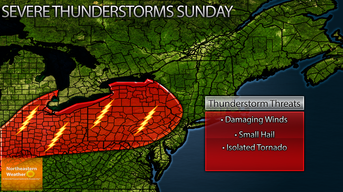
My thinking on where severe weather is most likely later this morning into late this afternoon/early this evening:
Severe weather is looking likely for a good chunk of Pennsylvania, possibly far west New Jersey and portions of western Upstate New York.
Storms are ongoing this morning in far southern Michigan. A line of weak showers and storms also just exited Indiana and is moving into eastern Ohio.
These two areas of convection will be most favored for development into a line of severe thunderstorms, beginning around 11 am and ending after 5 PM or so.
As the storms move into eastern Ohio, instability will have increased sufficiently to allow for pretty rapid strengthening/organization of storms. Vertical winds in the atmosphere will favor a few damaging wind gusts in this line of storms.
The main line of storms itself appears to move from Eastern Ohio and across most of Pennsylvania, as well as some of western upstate NY.
For portions of western Ohio, and northern Indiana/Southern Michigan, the line of storms will clear quick enough this morning that enough instability/shear will be present for more scattered severe storms this afternoon, some of which could produce hail, damaging winds and a few isolated tornadoes.
A few isolated tornadoes are also possible in the main line of storms, however due to the structure of storms/weak low level winds in the atmosphere, they are not likely at this time for ANY storm in the area.
This line of storms will progress and eventually weaken into an area of showers/isolated thunderstorms, which will be capable of producing flash flooding on an isolated scale across portions of northeast New York/wester New England.
My thinking on where severe weather is most likely later this morning into late this afternoon/early this evening:

 RSS Feed
