As of the evening hours on Sunday, February 1 models have generally come into great agreement on a storm system that will track off of the New Jersey coast on Sunday night and just off of Cape Cod on Monday. This will spread a significant snowfall across much of the area.
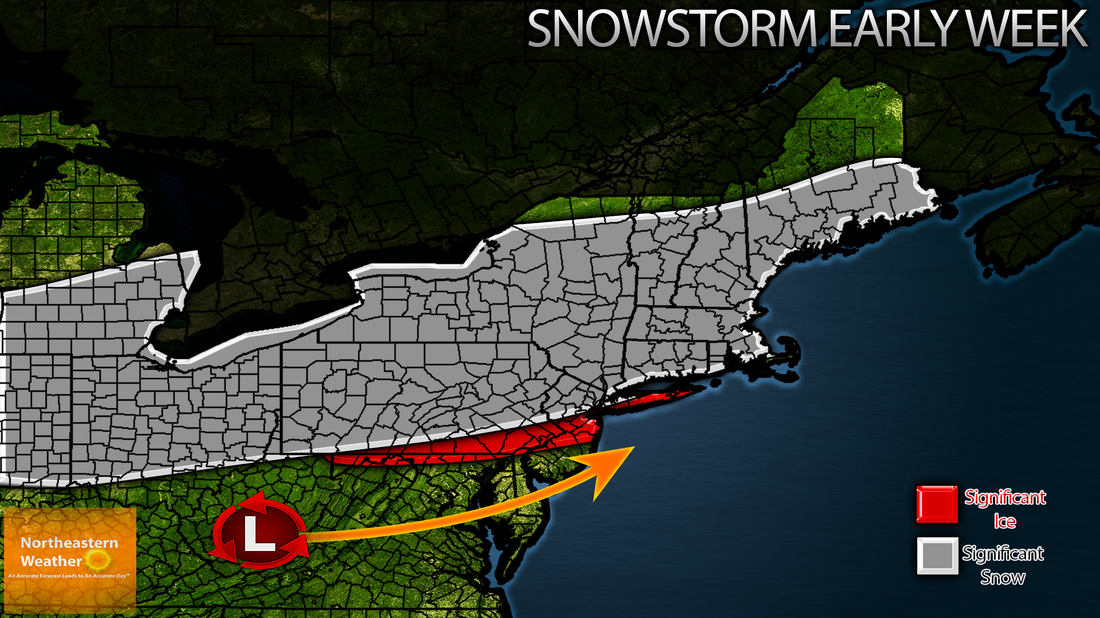
As the low tracks across Tennessee Saturday night and Sunday snow will spread into places like Ohio and Pittsburgh, Pennsylvania. Snow will become heavy in these areas by afternoon. The low will continue it's trek east, across West Virginia and into southern New Jersey by Sunday night. This will spread heavy precipitation across eastern and central Pennsylvania, NYC Metro, and New Jersey Sunday night into Monday. Across southeastern Pennsylvania and Southern New Jersey, I expected snow to go over to rain, holding accumulations down to below 3" there. NYC is expected to be right on the edge of mixing, and right now I'll go with 5-8" of snow with some ice possible there as well. The low will track off of the New Jersey coastline early Monday morning and begin to track northeast. This will spread snow into Southern New England and the Maine Coastline early Monday morning. Snow will be heavy at times in these areas during the day on Monday, with wind gusts towards 40 MPH potentially leading to scattered whiteout conditions.
Significant ice accretion (accumulation) will also be possible across the NYC metro area into the Philadelphia metro area. Ice accretions of between 1/10 of an inch to as much as 1/2 of an inch are possible somewhere in this corridor, but it is too early to pinpoint exactly where, so stay tuned.
Accumulations for Major Cities:
Buffalo- 12-18"
Pittsburgh- 1-3"
Philadelphia- Dusting to 1" MAYBE Trace of Ice Possible
Newark- 1-3"
New York City- 1-3" Up to 1/4 of an inch of ice.
Hartford- 5-8" Up to 1/10 of an inch of ice
Boston- 5-8" Trace of Ice Possible
Portland- 12-18"
Bangor- 8-12"

 RSS Feed
