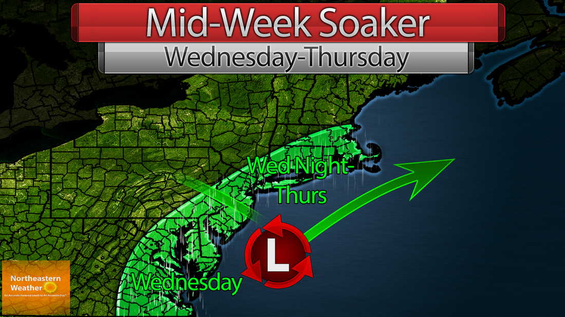
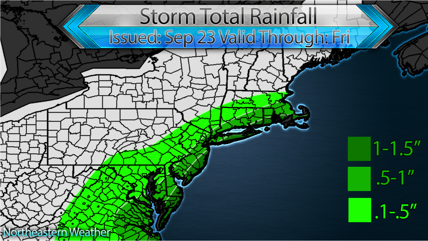
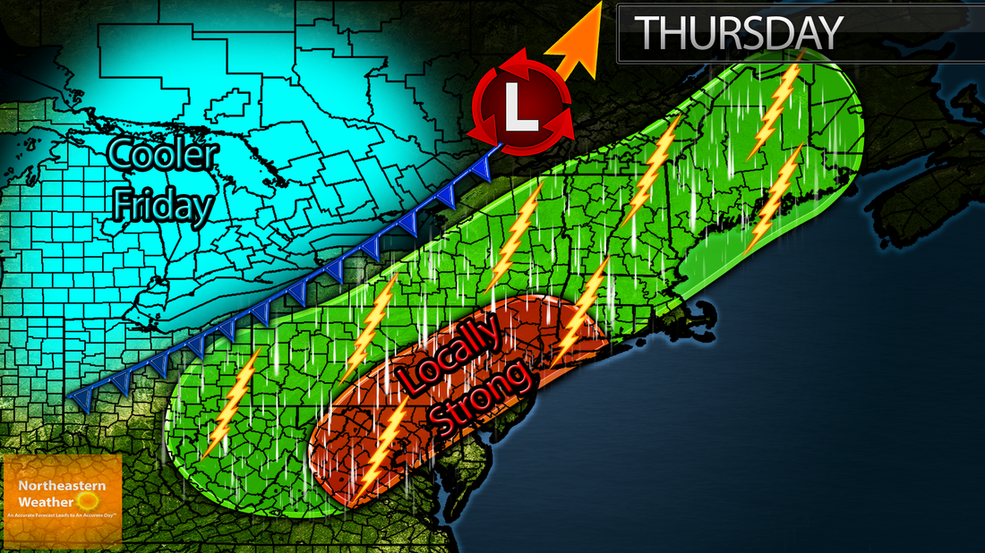
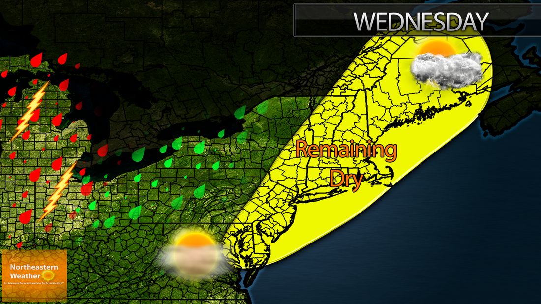
A drenching rain is appearing more and more likely for the mid atlantic and i95 corridor beginning Wednesday and working North into Thursday. Rainfall amounts could approach 2 inches in some localized spots, especially along the immediate coast. A few showers may reach Northern New England, but they will for the most part be saved by high pressure that will help keep the air dry and the rain out.
Saturday will feature mostly sunny skies with highs in the upper 60's to lower 70's for most, the exception being most of Northern New England, which has found itself stuck in the clouds with highs in the upper 50's to lower 60's likely. There will be a pressure gradient over the area for most of the day Saturday and Saturday night, which will cause winds to gust out of the southeast up to 40 MPH for some areas. Not too much, but anything that might blow around in the yard should be secured. Overnight lows are not concerning me Saturday night thanks to the winds, so frost isn't expected for areas that still are in growing season. As Sunday rolls around, the areas will be under the influence of two systems. System number 1 is a cold front advancing from the west, and System number 2 is a weak but large area of low pressure moving up the coast. The weak area of low pressure will keep clouds and showers (Some of which may be widespread) around for the coast, while the cold front will keep showers and scattered thunderstorms (Some of which may be gusty) around for inland areas. The front kicks the low pressure out to sea Sunday afternoon and passes off the coastline by Monday morning. Behind the front, colder air rushes in from the west, with highs a good 10-20° colder than Sunday's in store for Monday. The good news is that in the long term, precipitation looks unlikely through Tuesday. An update to this story will be posted Sunday morning.
Well, we knew it had to come sometime. Clear skies, light winds, and arctic high pressure will set the stage for a VERY cold Thursday night. Lows in sheltered inland locations could dip into the 20's, with widespread mid 30's expected. Frost will occur over much of the Northeast, and a freeze is likely over parts of New York, Vermont, New Hampshire, Pennsylvania, and Maine. The I95 corridor will not see a frost, but temps will easily dip into the low 40s, well below average for this time of year. Temperatures will tend to rebound a bit on Friday, reaching into the mid 60's for most.
Monday starts chilly but will likely turn mostly sunny with highs in the low to mid 60's likely. We will be under the influence of high pressure so that also means low humidity. Have a great day! major city forecasts:Bangor: Mostly sunny with a high around 62.
Portland: Mostly sunny with a high around 60. Boston: Mostly sunny with a high around 67. New York City: Mostly sunny with a high around 71. . Philadelphia: Mostly sunny with a high around 70. Saturday will feature cloudy to partly cloudy skies with highs in the mid to upper 60's, as well as widespread-scattered showers for much of the area. Showers in Maine could be a little heavy, due to the development of a secondary ocean low that may funnel some moisture into the other system. Either way, it'll be a dreary day. Nicer weather appears to return Sunday. major city forecasts:Bangor: Partly cloudy with a high around 64. A 40% chance of showers after 5 PM. Portland: Partly cloudy with a high around 64. A 40% chance of showers after 4 PM. Boston: Partly cloudy with a high around 67. A 40% chance of showers after 3 PM. New York City: Partly cloudy with a high around 70. A 40% chance of showers after 12 PM.
The cold front that brought us wet and stormy weather Thursday will move offshore Friday, leaving cold high pressure and gusty winds in it's wake. Those winds will gust upwards of 35 MPH during the morning, and will be from the northwest, which will make it feel very chilly. The highs tomorrow should only get up to the low 70's, and that's in the usual warm spots. They will average in the upper 60's. Sunshine will dominate the area tomorrow as high pressure keeps only a few isolated fair weather clouds in the forecast. Looking ahead, the weekend looks nice too, with below average temps but at least partly sunny weather prevailing. We do have to watch Saturday for some scattered afternoon showers and more clouds. Major city forecasts:Bangor: Mostly sunny, with a high around 64.
Portland: Mostly sunny, with a high around 66. Boston: Mostly sunny, with a high around 69. New York: Mostly sunny, with a high around 71. Philadelphia: Mostly sunny, with a high around 71. Due to a cold front making it's way south as low pressure spins off to the northeast, we should see mostly cloudy skies and widespread rain showers for much of the day on Thursday. Scattered thunderstorms are possible as well, and some of those may contain gusty winds across parts of the mid-atlantic region. Any thunderstorm will have the potential to produce heavy rain. Looking ahead, the cooler weather behind the front will make for another nice "fallish" day on Friday. MAJOR CITY FORECASTSBangor: Mostly cloudy with a 60% chance of showers and thunderstorms. A high around 65.
Portland: Mostly cloudy with a 70% chance of showers and thunderstorms. A high around 64. Boston: Mostly cloudy with a 50% chance of showers and thunderstorms. A high around 65. New York City: Mostly cloudy with a 60% chance of showers and thunderstorms. A high around 67. Philadelphia: Mostly cloudy with a 60% chance of showers and thunderstorms. A high around 69. Much like Tuesday, Wednesday will be a "10/10" day for some, and a "5/10" day for others. Western PA, and Western Upstate NY are penciled in for a mostly cloudy sky, however, the clouds will be thin and high, so there might be a few peaks of sunshine even there. As you get closer to the coast and farther from a strong low pressure system to the west, you will see more sun and less of a chance of showers. Speaking of showers, there will be about a 20% chance of em' from Western PA through Upstate Western NY. Even a rumble of thunder wouldn't surprise me in southwestern PA. Major city forecasts:Bangor: Partly sunny with a high around 72.
Portland: Partly sunny with a high around 68. Boston: Partly sunny with a high around 70. New York City: Partly sunny with a high around 72. Philadelphia: Partly sunny You've noticed by now that our old site is now directing you to this new one! We are pleased to present the new and improved Northeastern Weather website powered by weebly, soon to have our own domain! A few things about the new site and what you should know:
1. We are still at work. Some things may not work properly, and please be patient with us. 2. Our current URL is not our URL forever. We are going to be located at a new URL beginning October 1st. 3. We realize we changed early. We decided hey, why not get a head start! 4. Yorecast will remain available on the old site, but until October 1st, it will not be available here. We apologize. 5. Thank you so much! |
WEATHER ALERTS:
|