For the past few days, most major computer models have indicated the potential for a significant winter storm to impact the area. This trend continues, and I now feel confident in saying that the area will be impacted by a significant winter storm, mainly on Christmas eve. This blog post will focus on the public-impact of this system, so for a more in-depth analysis of the system, see the Winter Weather Center.
The actual track of this system appears to be over the Ohio Valley into Michigan. This keeps much of the Northeast in the "warm sector" of the storm, and although I can't rule out a mix at times for far northern areas, I feel pretty confident in saying that this system will bring mostly (heavy) rain to the area. In fact, highs will likely reach into the upper 50s for many areas Wednesday. Here's a map of the DOMINANT impacts I expect from this system:
The actual track of this system appears to be over the Ohio Valley into Michigan. This keeps much of the Northeast in the "warm sector" of the storm, and although I can't rule out a mix at times for far northern areas, I feel pretty confident in saying that this system will bring mostly (heavy) rain to the area. In fact, highs will likely reach into the upper 50s for many areas Wednesday. Here's a map of the DOMINANT impacts I expect from this system:
This post will be updated frequently as new details regarding this system emerge, so stay tuned in the coming days.
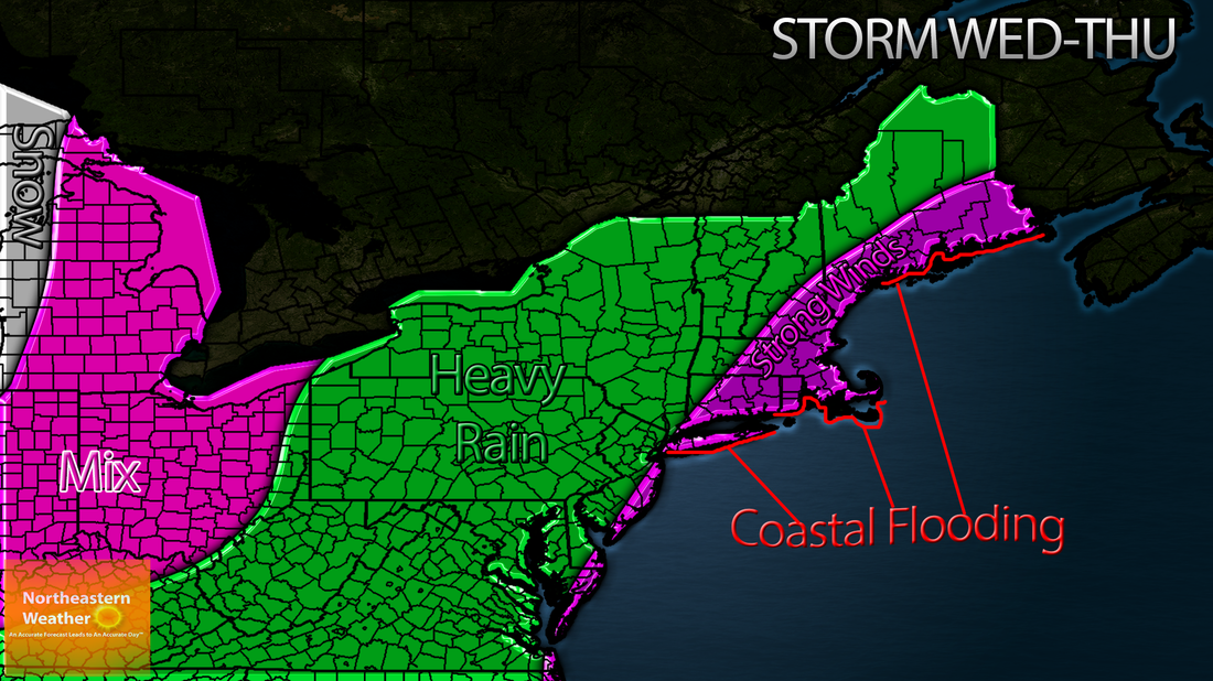
The storm will have an impact on Christmas travel across the region, especially along the coast. Now, although the strongest winds will be along the coast, the system will bring gusty winds to all areas. This combined with heavy rain will be enough to make it difficult to even drive. And when I say heavy, I mean HEAVY. Early indications area that 1-3 inches of rain could fall across much of the region, with locally higher amounts to 4 inches possible.
Travel Tuesday shouldn't be too bad across the area, with most places just seeing scattered to numerous light showers, and gusty wind. The only implication is that any area away from the coast that sees precipitation on Tuesday is subject to a bit of a wintry mix, as the warmer air will not yet have established itself across the area.
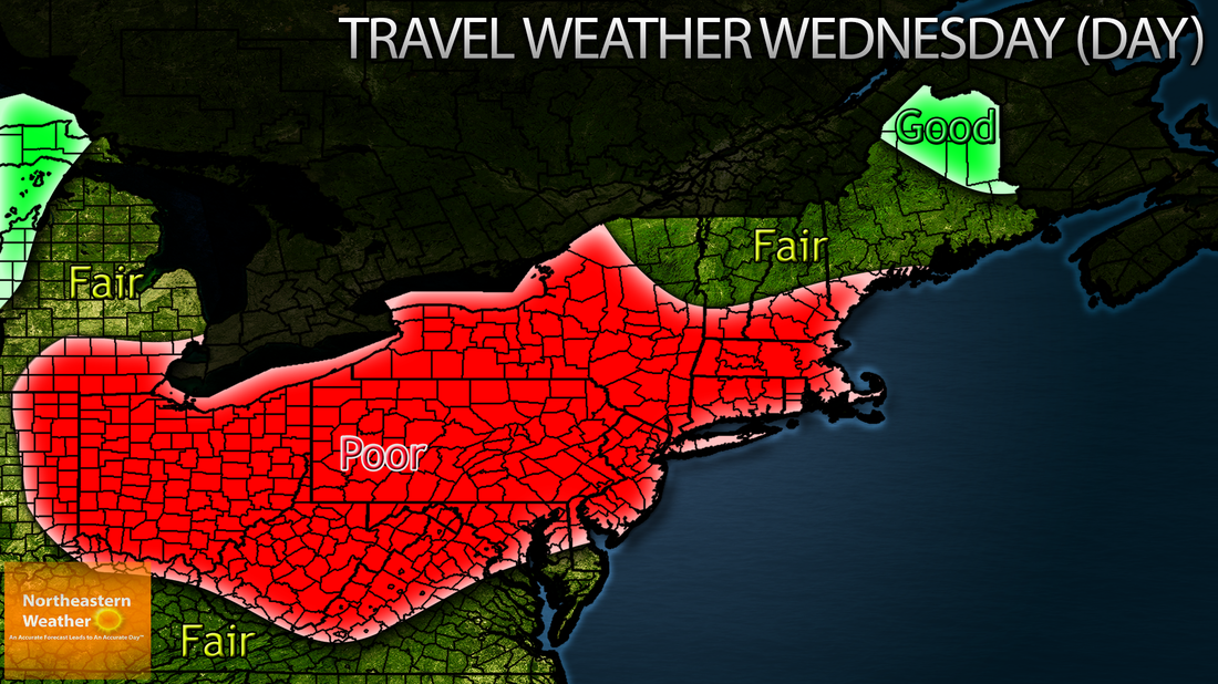
Wednesday is where it gets interesting. About the only area of good travel in the Northeast will be across Northern Maine, where precipitation won't have had a chance to reach yet. Fair travel with a light rain and a breeze is likely across much of Northern New England, with southern New England on seeing poor travel. Logan Airport, JFK Airport, La Guardia Airport and Philadelphia Airport are all likely to see delays on Wednesday. Here is a map of the travel conditions that I expect Wednesday:
Travel Tuesday shouldn't be too bad across the area, with most places just seeing scattered to numerous light showers, and gusty wind. The only implication is that any area away from the coast that sees precipitation on Tuesday is subject to a bit of a wintry mix, as the warmer air will not yet have established itself across the area.
Wednesday is where it gets interesting. About the only area of good travel in the Northeast will be across Northern Maine, where precipitation won't have had a chance to reach yet. Fair travel with a light rain and a breeze is likely across much of Northern New England, with southern New England on seeing poor travel. Logan Airport, JFK Airport, La Guardia Airport and Philadelphia Airport are all likely to see delays on Wednesday. Here is a map of the travel conditions that I expect Wednesday:
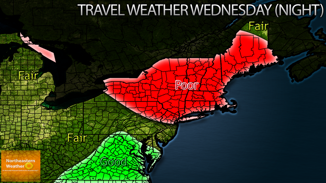
Wednesday night poor travel conditions will spread north, engulfing New England, but travel conditions stand to improve some across much of Pennsylvania and New Jersey. However, gusty winds behind the system will continue to impact the area, leading to only fair travel conditions. Here is a map of the travel conditions I expect Wednesday NIGHT:
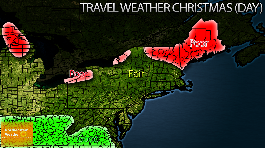
For the holiday itself, travel conditions will improve for most. However, areas around the Great Lakes will have to contend with lake-effect snow, as winds align just right. Eastern Maine will still be under the influence of the system, so travel conditions remain poor there. Winds will remain gusty across the entire area, so some moderate travel delays are still likely. Here is a map of the travel conditions I expect on Christmas DAY:
This blog post will be updated frequently up to the event, so stay tuned!
 RSS Feed
