For the past few days you have all likely been hearing of a snowstorm that may impact the Northeastern United States in the next week or so. There is potential, however, it is being overdone by some media outlets.
Most areas along the coast of the Northeast have not seen a significant snowfall yet this year. This is likely making people very anxious for when the first blanket of snow will arrive. Don't fret, it'll happen. But, "wishcasting" as I like to call it, won't help a thing. If a storm isn't going to happen, it doesn't help to lie to everyone and release maps making it look like it will. Just make sure you all get your weather info from a TRUSTED source. Now, onto this weekends storm.
For the past week or so, models have been hinting at the potential for SOMETHING to develop off the coast of the Northeast. There are still mixed feelings among the tools we use to forecast the weather, basically meaning this storm can't be officially "forecasted" yet. However, the word potential can and will be used a lot, and I do have a map of my guess of SOME impact There are multiple scenarios with this system.
Scenario 1: Storm develops too far south, keeping any impacts minimal for the area, but much colder air will arrive for the weekend (it's kinda a pick your poison scenario here folks). This scenario is favored by a few of the models (or tools that we use to forecast)
Scenario 2: Storm develops off the NJ coastline, and moves north near the coast, but far enough offshore to keep the worst impacts away. This scenario is also favored by a few models, and personally by me. The Ensemble forecast that we use (basically all the models lumped together) is trending towards this, although each individual model may not. It also makes more sense, with high pressure to north, but not close enough to push the system out to sea. For now, here's my map. I'll update this story periodically throughout the week as we get closer to the event.
Most areas along the coast of the Northeast have not seen a significant snowfall yet this year. This is likely making people very anxious for when the first blanket of snow will arrive. Don't fret, it'll happen. But, "wishcasting" as I like to call it, won't help a thing. If a storm isn't going to happen, it doesn't help to lie to everyone and release maps making it look like it will. Just make sure you all get your weather info from a TRUSTED source. Now, onto this weekends storm.
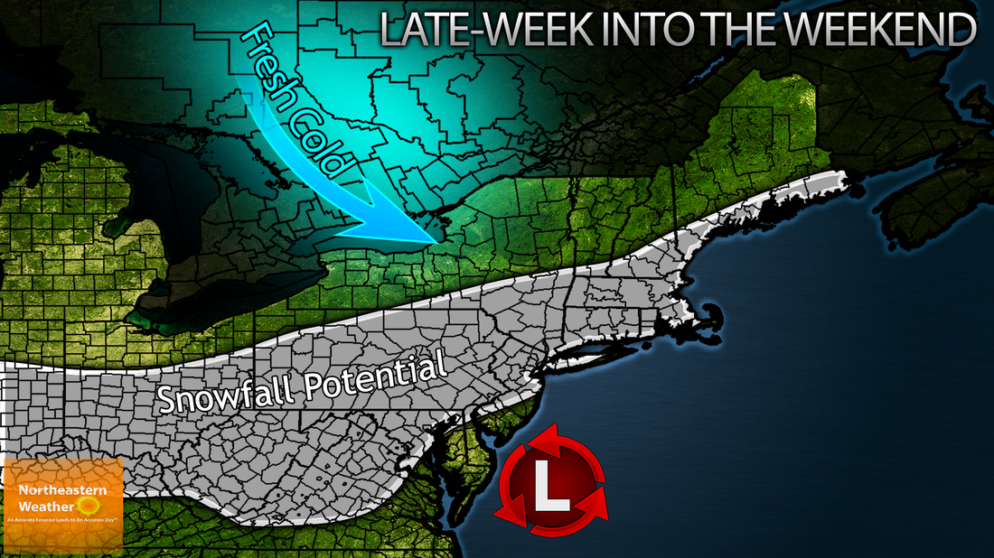
For the past week or so, models have been hinting at the potential for SOMETHING to develop off the coast of the Northeast. There are still mixed feelings among the tools we use to forecast the weather, basically meaning this storm can't be officially "forecasted" yet. However, the word potential can and will be used a lot, and I do have a map of my guess of SOME impact There are multiple scenarios with this system.
Scenario 1: Storm develops too far south, keeping any impacts minimal for the area, but much colder air will arrive for the weekend (it's kinda a pick your poison scenario here folks). This scenario is favored by a few of the models (or tools that we use to forecast)
Scenario 2: Storm develops off the NJ coastline, and moves north near the coast, but far enough offshore to keep the worst impacts away. This scenario is also favored by a few models, and personally by me. The Ensemble forecast that we use (basically all the models lumped together) is trending towards this, although each individual model may not. It also makes more sense, with high pressure to north, but not close enough to push the system out to sea. For now, here's my map. I'll update this story periodically throughout the week as we get closer to the event.
 RSS Feed
